Dear users,
Due to development and transition to a new website for the Executive Agency "Research and Maintenance of the Danube River", a problem might occur with accessing the information we publish.
We assure you that the problem is temporary, and we are working hard to provide you with a more complete and better view of the information you need.
Please excuse us for this inconvenience!
With respect - The APPD team.
| station | kilometre | water level (cm) | discharge (m3/s) | 24 hours difference (cm) | t water(°C) |
| Novo selo | 833.60 | 282 | 5102 | -4 | 15.2 |
| Lom | 743.30 | 337 | 4971 | -16 | 15.8 |
| Oryahovo | 678.00 | 238 | 5318 | -7 | 17.0 |
| Nikopol | 597.50 | 306 | -4 | 16.1 | |
| Svishtov | 554.30 | 276 | 5554 | -4 | 16.4 |
| Ruse | 495.60 | 273 | 5531 | -1 | 16.5 |
| Silistra | 375.50 | 287 | 5616 | +2 | 16.9 |
After 7:00 o´clock water levels are shown in grey denoting they were taken the day prior. Once entered by the person on duty, digit colour updates to blue to denote current water level.
| station | kilometre | water level [cm] | last 6 hours difference | t water [°C] | |||
| Novo Selo | 833.60 |
 |
285 |
|
16.4 | ||
| Gomotartsi | 819.00 | 165 |
|
16.7 | |||
| Vidin-Kalafat bridge | 796.00 | 321 |
 |
||||
| Kozloduj | 703.90 | 110 |
 |
17.8 | |||
| Oryahovo | 678.00 | 233 |
|
18.2 | |||
| Bajkal | 640.80 | 83 |
|
18.1 | |||
| Zagrazhden | 625.00 | 103 |
|
17.2 | |||
| Nikopol | 597.50 | ||||||
| Svishtov | 554.30 | 269 |
|
18.2 | |||
| Ruse-Gurgue bridge | 488.70 | 269 |
|
||||
| Ryahovo | 465.40 | 39 |
|
17.9 | |||
| Malak Preslavets | 413.90 | 108 |
|
18.7 | |||
| Silistra | 375.50 | 283 |
|
16.8 |
| Part | Date of measurement | Scheme | Depth left (dm) |
Depth middle (dm) |
Depth right (dm) |
Width (m) | ||
| Chaika island, km 387.000 - 385.000 | 10.04.2024 | download | 47.7 | 41.7 | 38.7 | 150 | ||
| Garvan island, km 407.000 - 404.000 | 13.03.2024 | download | 39.7 | 46.7 | 50.7 | 150 | ||
| Albina island, km 414.000 - 412.000 | 13.03.2024 | download | 47.7 | 49.7 | 44.7 | 150 | ||
| Dunavets, km 423.000 - 421.000 | 12.03.2024 | download | 52.7 | 60.7 | 59.7 | 140 | ||
| Kosui island, km 425.000 - 423.000 | 11.04.2024 | download | 59.7 | 63.7 | 56.7 | 140 | ||
| Kosui island 2, km 428.000 - 425.000 | 11.04.2024 | download | 48.7 | 55.7 | 46.7 | 140 | ||
| Bryshlian island, km 458.000 - 454.000 | 10.04.2024 | download | 56.3 | 55.3 | 49.3 | 160 | ||
| Mishka island, km 463.000 - 460.000 | 14.03.2024 | download | 44.3 | 55.3 | 50.3 | 160 | ||
| Dunav Most, km 489.000 - 486.000 | 08.12.2023 | download | 56.3 | 56.3 | 150 | |||
| batin island, km 525.000 - km 522.000 | 23.04.2024 | download | 47.3 | 54.3 | 51.3 | 140 | ||
| km 530.000 - 527.000 | 04.04.2024 | download | 47.6 | 46.6 | 41.6 | 160 | ||
| Vardim island, km 545.000 - 542.000 | 03.04.2024 | download | 39.6 | 43.6 | 44.6 | 130 | ||
| Vardim island, km 547.000 - 544.000 | 18.04.2024 | download | 34.6 | 37.6 | 35.6 | 120 | ||
| Belene island, km 565.000 - 563.000 | 24.04.2024 | download | 42.6 | 45.6 | 40.6 | 140 | ||
| G. Byrzina island, km 576.000 - 573.000 | 24.04.2024 | download | 40.6 | 42.6 | 44.6 | 150 | ||
| Palets island, km 586.000 - 584.000 | 24.04.2024 | download | 40.6 | 55.6 | 47.6 | 160 | ||
| Lakyt island, km 591.000 - 589.000 | 11.01.2024 | download | 46.6 | 50.6 | 50.6 | 150 | ||
| Somovit, km 609.000 - 607.000 | 24.04.2024 | download | 41.6 | 40.6 | 44.6 | 140 | ||
The RIS index is a list of location codes (ISRS) with additional information about the objects, such as characteristics (name, fairway, ...), limitations (depth, bridge clearance, transmission line, ...), working hours...
Software for visualizing electronic maps, can be downloaded from the website 7Cs(www.sevencs.com) If you have any suggestions or comments about actual charts, please send to e-mail: stoyanov@appd-bg.org
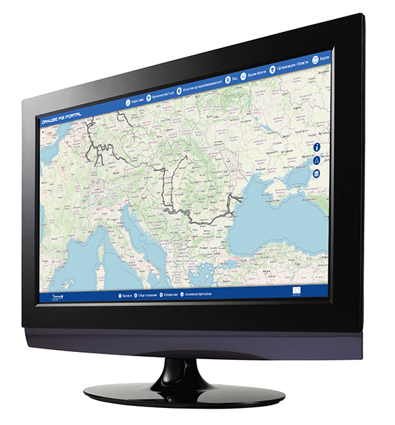
The FIS portal is the main information portal for the users of the waterway of the Danube river regarding fairway information. The portal provides up-to-date information on water levels, critical sections, ice phenomena, as well as notifications to ship owners. In addition, information on various water object on the river (bridges, locks, ports), contacts of responsible institutions, as well as electronic and paper navigation maps can be found on it. The FIS portal is available at the web address: www.danubeportal.com and is available in English, German, Slovak, Hungarian, Croatian, Serbian, Romanian and Bulgarian.
DISMAR co-funding contract was signed
Доклад по ОС и ОВОС по проект FAST DANUBE
ИАППД финализира успешно проект за обновяване на хидрографската си техника